


Descripción de BackCountry Navigator XE: Outdoor GPS App (New)
Welcome to the next generation of a product for exploring the outdoors on your own terms, using offline topo maps and GPS on your smartphone.
You can also subscribe to the XE List to get notified of status, updates, and deals.
While many of the goals of the new app are the same, we are hoping to achieve a number of goals with the new platform:
Cross-Platform
The original BackCountry Navigator PRO is only available on Android. We will be bringing BackCountry Navigator XE to Android, iOS and the web.
The corresponding app for iOS will be launched through TestFlight
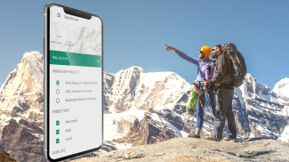
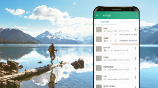
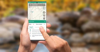
Planning In The Cloud
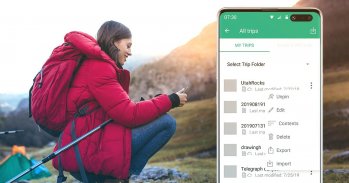
The website bcnavxe.com is the web interface for BackCountry Navigator XE. With it you can plot points, routes, and boundaries for trips, and download them on demand in the mobile app. You can push trips created in the mobile app to the cloud as well for reviewing or sharing.
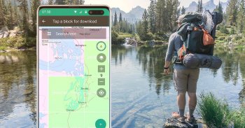
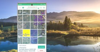
Easy Grid Based Download of Maps
You can try out a simpler approach for downloading and organizing offline maps, choosing large squares at a time. Visualize what you have and what you need.
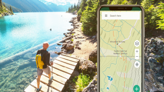
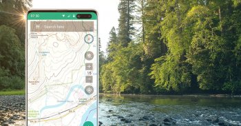
Vector Topo Maps for the World
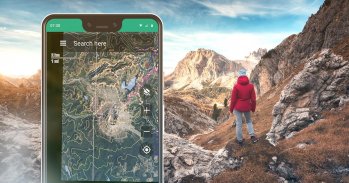
Vector topo maps for the world hold the promise of crisp multilevel detail, with the ability to download large chunks of the earth's surface in a quick, compact operation. The BackCountry topo map for the world can be viewed in this app and on bcnavxe.com, with an easy process to install them in large blocks.
SALE: 5 and 10 year plans now available for a limited time at bcnavxe.com.
Use coupon SUB2020 to save even more before the end of the month.
If you are looking for an already proven and established product, also consider BackCountry Navigator PRO. Support and development of that app continues on a parallel track.
https://play.google.com/store/apps/details?id=com.crittermap.backcountrynavigator.license
Bienvenido a la próxima generación de un producto para explorar el aire libre en sus propios términos, utilizando mapas topográficos fuera de línea y GPS en su teléfono inteligente.
También puede suscribirse a la Lista XE para recibir notificaciones sobre el estado, las actualizaciones y las ofertas.
Si bien muchos de los objetivos de la nueva aplicación son los mismos, esperamos alcanzar varios objetivos con la nueva plataforma:
Multiplataforma
El BackCountry Navigator PRO original solo está disponible en Android. Llevaremos BackCountry Navigator XE a Android, iOS y la web.
La aplicación correspondiente para iOS se lanzará a través de TestFlight
Planificación en la nube
El sitio web bcnavxe.com es la interfaz web para BackCountry Navigator XE. Con él puede trazar puntos, rutas y límites para viajes, y descargarlos a pedido en la aplicación móvil. También puede enviar viajes creados en la aplicación móvil a la nube para revisarlos o compartirlos.
Descarga de mapas basada en una cuadrícula fácil
Puede probar un enfoque más simple para descargar y organizar mapas sin conexión, eligiendo cuadrados grandes a la vez. Visualiza lo que tienes y lo que necesitas.
Mapas topográficos vectoriales para el mundo
Los mapas topográficos vectoriales para el mundo prometen detalles nítidos de varios niveles, con la capacidad de descargar grandes porciones de la superficie de la tierra en una operación rápida y compacta. El mapa topográfico BackCountry para el mundo se puede ver en esta aplicación y en bcnavxe.com , con un proceso sencillo para instalarlos en bloques grandes.
VENTA: planes de 5 y 10 años ahora disponibles por tiempo limitado en bcnavxe.com.
Use el cupón SUB2020 para ahorrar aún más antes de fin de mes.
Si está buscando un producto ya probado y establecido, considere también BackCountry Navigator PRO. El soporte y desarrollo de esa aplicación continúa en una pista paralela.
https://play.google.com/store/apps/details?id=com.crittermap.backcountrynavigator.license
BackCountry Navigator XE: Outdoor GPS App (New) - Versión 2.8.1
(03-09-2023)BackCountry Navigator XE: Outdoor GPS App (New) - Información de APK
Version de la app: 2.8.1Paquete: com.crittermap.backcountrynavigator.xeÚltima versión de BackCountry Navigator XE: Outdoor GPS App (New)
Apps en la misma categoría
Quizá también te interese...


